
|
The Milpitas
Community
|
In 2013 the Milpitas Community Museum was incorporated as a non-profit corporation. Here is more information about the Museum.
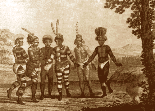
We know of one Muwekma Ohlone Indian
village in the over fourteen square miles covered by the city
today. It is buried several feet under soil hauled in on which
to build the Calvary Assembly of God Church complex near the
corner of Calaveras Road and Old Piedmont Road. A description of
the life of the early Indians may be found in Madge Craig's The
History
of Milpitas.
For thousands of years, these natives built several large
cemeteries which Europeans later called "shell mounds." A number
of these cemeteries are located under the businesses lining Main
Street and early builders occasionally unearthed the remains and
artifacts left by these First Americans according to Tom Evatt,
Milpitas' first mayor.
 These hills of
dirt were the result of ceremonies marking the anniversary of
the death of a loved one. At the appointed time, relatives of
the deceased were host to a "crying ceremony" which was attended
by people from near and far. Sometimes the bereaved numbered in
the thousands. For three to five days there was feasting and
ritual mourning for the departed at the cemetery. The leavings
from the mourners' meals of bay shellfish stayed at the cemetery
(there were no garbage collectors to haul it away). Layers of
dirt, animal bones, shells next to the Indian burials resulted
in the large mounds.
These hills of
dirt were the result of ceremonies marking the anniversary of
the death of a loved one. At the appointed time, relatives of
the deceased were host to a "crying ceremony" which was attended
by people from near and far. Sometimes the bereaved numbered in
the thousands. For three to five days there was feasting and
ritual mourning for the departed at the cemetery. The leavings
from the mourners' meals of bay shellfish stayed at the cemetery
(there were no garbage collectors to haul it away). Layers of
dirt, animal bones, shells next to the Indian burials resulted
in the large mounds.
In 1993, a portion of such a mound cemetery was excavated at the Elmwood
Correctional Facility. The
Ohlone Families Corp. was contracted to disinter the human
remains. It marked one of the first times in California history
where local Native Americans were hired to remove the bones of
their own ancestors. Over 150 remains of individuals were
carefully removed and boxed for reinternment. Found with the
remains were artifacts which indicate that as early as the
fifteenth century local tribes were trading with others from Monterey Bay (abalone
and other shell necklaces) to the Sacramento area
(scrimshaw
bird bone ear ornaments). Jasper from the Morgan Hill area 25
miles to the south was also found.
The first Europeans arrived in Milpitas overland with the De Anza expedition. A soldier with the expedition, José Higuera, was awarded a land grant by the last Spanish governor of Alta California, Pablo Vincinté de Sola, in 1821. Named Rancho Tularcitos, it covered 4,394.35 acres of what is today central and northern Milpitas. Soon after being given the land, Higuera built a one story adobe. The ruins of the adobe are within the walls of another structure built in the 1960s by Mrs. Marion Weller. This may be seen and visited at Higuera Adobe Park on North Park Victoria Drive.
The border of Milpitas and Fremont was the location of Rancho Agua Calienté. Its 9,563.87 acres were granted to Fulgencio Higuera in 1839, in part with land taken from the San José Mission following the secularization of Church property by the Mexican government.
To the west of Penitencia Creek (which originally ran just behind the buildings on the west side of Main Street) was Rancho Rincon de los Esteros. The 6,352.9 acres of brackish marshes and prime bottom land was granted to another of De Anza's soldiers, Juan Ignacio Alviso. He was the man for whom the Alviso district of San José was named. Alviso district has over 20 structures listed on the National Register of Historic Places, however it is not known to us where Alviso's hacienda was located, perhaps he made his home in Pueblo San José*, which was nearby.
The central and southern portions of Milpitas were part
of Rancho
Milpitas. It comprised
4,457.66 acres roughly bordered by Calaveras Road which ran just
to the west of Los Cochés Creek in the north, Berryessa Creek to
the sout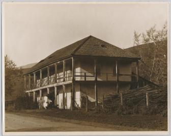 h, and Penitencia Creek to the
west. It was granted to José Maria de Jésus Alviso in
1835. He named his new land, Rancho San Miguel. In
that year, Alviso built a three-room adobe house on the low
foothills near the corner of Piedmont Road and Calaveras Road
[See image at right]. This adobe brick-walled hacienda, for
which our city was named, had a second story made of wood added
in 1853 probably shortly before or after Alviso's death in the
summer of 1853. Until it was acquired by
the city in 1996, this was one of the oldest
continually inhabited adobe structures in the state. Our city
was named after Alviso's rancho by Joseph Weller when the first
U.S. Post Office was opened on Main Street, but according to
Madge Craig's book The History of Milpitas, many locals
had taken to calling the collection of buildings at the
crossroads along Penitencia Creek, "Penitencia" after the small
Catholic building next to the creek that was
used by the Spanish Padres to hear confession by the nearby
natives. The word Milpitas
is the diminutive of Milpa, which is derived from a
Nahuatl word for "place were corn grows". It was the word
the Spanish/Mexicans used to denote a Native American vegetable
garden. In the original land grant, Alviso was given "the
land known as Milpitas". So it is possible that the Ohlone
who had lived in the village at that site had well-known small
gardens or milpitas.
[See: Origin
of Milpitas video]
h, and Penitencia Creek to the
west. It was granted to José Maria de Jésus Alviso in
1835. He named his new land, Rancho San Miguel. In
that year, Alviso built a three-room adobe house on the low
foothills near the corner of Piedmont Road and Calaveras Road
[See image at right]. This adobe brick-walled hacienda, for
which our city was named, had a second story made of wood added
in 1853 probably shortly before or after Alviso's death in the
summer of 1853. Until it was acquired by
the city in 1996, this was one of the oldest
continually inhabited adobe structures in the state. Our city
was named after Alviso's rancho by Joseph Weller when the first
U.S. Post Office was opened on Main Street, but according to
Madge Craig's book The History of Milpitas, many locals
had taken to calling the collection of buildings at the
crossroads along Penitencia Creek, "Penitencia" after the small
Catholic building next to the creek that was
used by the Spanish Padres to hear confession by the nearby
natives. The word Milpitas
is the diminutive of Milpa, which is derived from a
Nahuatl word for "place were corn grows". It was the word
the Spanish/Mexicans used to denote a Native American vegetable
garden. In the original land grant, Alviso was given "the
land known as Milpitas". So it is possible that the Ohlone
who had lived in the village at that site had well-known small
gardens or milpitas.
[See: Origin
of Milpitas video]
In the 1882, History
of Santa Clara County, Michael Hughes is credited as
the first non-Hispanic European to settle in Milpitas in 1852.
He probably built his redwood frame house near what is now the
intersection of Main and Carlo Streets. In March of 1853,
Hughes filed a pre-emption claim (AKA "Squater's Rights").
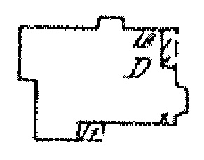
The 1893 Sanborn Fire Insurance map shows a frame house
just west of the present intersection on land homesteaded by
Ellen Hughes in 1868 and still owned by the Hughes family on the
County Assessor's Map of 1890. The image at left is from
the Sanborn Fire Insurance map of 1893 and shows a frame
domicile at the Hughes homestead site (Main St. is to the right
of the drawing).
The settlers who followed Hughes included Joseph Weller
(for whom Weller School is named), Dudley Wells, Joseph Murphy
(possibly for whom Murphy School site is named), Joseph Scott
(for whom Scott Creek is named), and Englishman, Frederick
Creighton (for whom Creighton Park is named). The main
crop they grew was wheat and a little barley. The latter
was probably sold to local breweries.
Although the History of Santa Clara County
credits Creighton as building the first store in Milpitas at the
corner of what is now Main
and Serra Streets in
1857, Augustus Rathbone, purchased the land "and
improvements" at the southwest corner of that intersection in
February 1856 from Richard Greenham for $1,200 -- a sum that
indicates structures were probably present. Rathbone
established a store and saloon at the site that is mentioned in
the diary of Alfred Doten in 1858, At
that time, Main Street was known as Mission Road because it
connected the Mission of San José with the Pueblo of San José.
Where Creighton and Rathbone operated their stores Mission Road
was intersected from the west by the Alviso-Milpitas Road.
It was in Rathbone's Saloon on February 21, 1865, that Bernad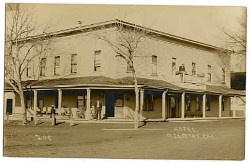 a
Zunaga was stabbed to death by Juan Rentaria, this was the first
recorded murder in Milpitas. Unfortunately, the murderer
escaped. .Across the Alviso road, to the north, Alex Anderson
first built a saloon and hotel in 1857 on land he rented from
Michael Hughes. This saloon/hotel was bought and sold
three times in 1859, but finally acquired by Alfred French, who
hailed from Ohio. Over the next 30 years the establishment
came to be called "French's Hotel".
a
Zunaga was stabbed to death by Juan Rentaria, this was the first
recorded murder in Milpitas. Unfortunately, the murderer
escaped. .Across the Alviso road, to the north, Alex Anderson
first built a saloon and hotel in 1857 on land he rented from
Michael Hughes. This saloon/hotel was bought and sold
three times in 1859, but finally acquired by Alfred French, who
hailed from Ohio. Over the next 30 years the establishment
came to be called "French's Hotel".
French's Hotel (see image at right) burned, was rebuilt, and in the 1890s, was renamed the Milpitas Hotel. This building burned in the town's great fire of 1910. By the mid 1920s one of the Fat Boy Barbeque Restaurants was erected on the site. The Fat Boy Restaurants were one of the first "fast food" chains in America. During this time Milpitas was a thriving highway service center on the road which now connected Oakland with San José. That highway is known today as Main Street.
When the Western
Pacific Railroad came
to Milpitas in 1867, the town got an 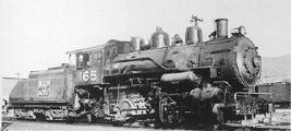 economic boost. A depot
was built southeast of St.
John's
Catholic Church next
to the railroad tracks on the site of a present day strip mall.
Tons of locally grown produce were loaded onto freight cars
there. Some was processed into cans at the California &
Pacific Cannery, located on the east side of Main Street
northeast of the church. Milpitas became famous for peas,
spinach, asparagus, beans, and later, strawberries.
economic boost. A depot
was built southeast of St.
John's
Catholic Church next
to the railroad tracks on the site of a present day strip mall.
Tons of locally grown produce were loaded onto freight cars
there. Some was processed into cans at the California &
Pacific Cannery, located on the east side of Main Street
northeast of the church. Milpitas became famous for peas,
spinach, asparagus, beans, and later, strawberries.
In the early twentieth century, hay to feed the thousands of horses in San Francisco, became the primary cash crop grown in Milpitas. Hay continued to be grown well into the 1980s when the remaining farmland east of Penitencia Creek was developed. The last farmland in the valley portion of Milpitas was the McCarthy Ranch. For many years, the McCarthy family operated a fruit and vegetable stand at the present site of McCarthy Blvd. overpass.
When the Ford Motor Assembly Plant came to the southern
edge of town, San José indicated interest in making it part of
that city. The local inhabitants fought back. The City of
Milpitas was the result of a
defensive incorporation on January 26, 1954. Later, in 1960, San
José attempted to incorporate our young city but was met 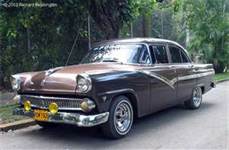 with a very
lopsided defeat in the election. The Minute Man was added to the
city's seal and flag following this campaign. Ironically, Ford
Corporation called the facility
the San Jose Ford Motor Assembly Plant. The automobile
manufacturing era in Milpitas lasted little more than a quarter
century. After the plant closed it remained largely unused for
nearly fifteen years. Today, it is the Great Mall of
the Bay Area.
with a very
lopsided defeat in the election. The Minute Man was added to the
city's seal and flag following this campaign. Ironically, Ford
Corporation called the facility
the San Jose Ford Motor Assembly Plant. The automobile
manufacturing era in Milpitas lasted little more than a quarter
century. After the plant closed it remained largely unused for
nearly fifteen years. Today, it is the Great Mall of
the Bay Area.
In 1980 the Milpitas Historical Society was formed. Through the efforts of its members the Milpitas City Council passed an ordinance to protect and preserve the city's cultural resources. The enforcement of that ordinance is assigned to the Parks, Recreation, and Cultural Resources Commission.
As the twenty-first century begins, few cities in America are as well balanced as the Milpitas community. There is a large and thriving retail business in the city as well as many computer technology manufacturing industries.
Contact Us by email at mcm at milpitashistory.org
A SAMPLER OF HISTORICAL PLACES IN MILPITAS
Here's a list of a few of the more than fifty historical places in Milpitas:
This website was created and is maintained by Steve Munzel. Last updated October 2017.